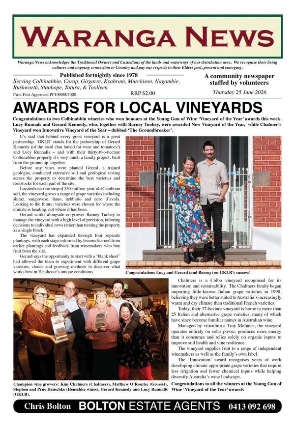
8. Custodianship of the land today

In the previous story, we looked at the traditional lands of the Ngurai-illum Wurrung people. It was noted that much of their country became the old Shire of Waranga after European settlement and included the sites of the present-day towns of Colbinabbin, Rushworth, Stanhope, Corop and Murchison. That raises some questions when you are moving around Ngurai-illum Wurrung today.
For instance, if you drive along the Midland Highway between Corop and Stanhope, a sign welcomes you to Yorta Yorta country. If you look at the signs at various sites around the area, like Stockyard Plain near Waranga Basin and the Police Paddocks at Murchison, they refer to the fact that you are on Yorta Yorta land. A similar situation exists to the south, where there are signs indicating that you are on Taungurung land. So where do our Ngurai-illum Wurrung people fit into all this?
REGISTERED ABORIGINAL PARTIES
Much of Victoria is covered by agreements between the State government and what are known as Registered Aboriginal Parties (RAPs). Broadly, what the RAPs do is involve Aboriginal people in managing and protecting Aboriginal cultural heritage in Victoria, as well as providing a range of services to the wider community. They administer the Aboriginal Heritage Act of 2006.
You can find out more about RAPs by using the following link –
https://w.www.vic.gov.au/aboriginalvictoria/heritage/registered-aboriginal-parties.html
The RAPs are incorporated bodies that are each responsible for a specific geographic area. In the absence of such a body representing the Ngurai-illum Wurrung people, the lands for which they were the original custodians came under the care of two RAPs – the Yorta Yorta Nation Aboriginal Corporation and the Taungurung Land and Waters Council Aboriginal Corporation.
This explains the apparently contradictory signage mentioned above. The places were once on Ngurai-illum Wurrung land, but they are currently cared for by the descendants of people who were originally neighbours of the Ngurai-illum Wurrung.
A FLUID SITUATION
Currently there are 12 declared RAPs in Victoria which cover much of the state’s geographic area. This number is not restrictive in that other organisations can apply to become a RAP. Eventually, the whole of Victoria might be under the custodianship of RAPs. The main areas not covered at present are in the semi-desert country in the north-west of the state around and parts of the Victorian Alps and East Gippsland.
It is possible for a certain geographic area to have two RAPs responsible for it. In future it could be conceivable that if the descendants of the Ngurai-illum Wurrung became a RAP, they could share responsibility for our area with the two groups mentioned above.
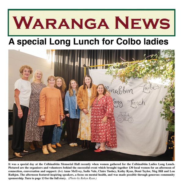
A PRACTICAL EXAMPLE
If an issue were to arise in relation to, say, the Aboriginal rock well at Whroo, the relevant RAP (currently Taungurung L&WCAC) would be consulted as the “primary guardians, keepers and knowledge holders of Aboriginal cultural heritage.” One example might be a situation where DELWP was thinking about improving the very inadequate infrastructure and total lack of interpretive data at the site of the rock well. They would need to liaise with the RAP first, even though they are a government department with responsibility for the area.
In the future, if there was a Ngurai-illum Wurrung group which went through the process to become a RAP, with responsibility for the former lands of the Ngurai-illum, then they would also need to be consulted. Reference: Victorian Aboriginal Heritage Council website