7. Chinese camps on Waranga goldfields

The Chinese miners and businesspeople on the Waranga goldfields tended to live in separate communities to the Europeans. There were various reasons for this. As a group, they suffered considerable racism from other residents of the goldfields, so it was safer to keep to themselves. Additionally, many of the miners were part of organised groups. Sometimes, the groups were comprised largely of men from the same village or local area back home. They shared language and customs. There were also people within the groups who had designated tasks, such as providing food for the miners at the end of a hard day and maintaining the camp.
CAMPS AT WHROO
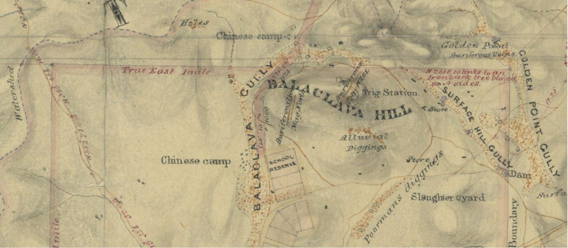
Source: Public Records Office Victoria – File GF31 Waranga Gold Fields 1857
There are contemporary maps of the Waranga goldfields which identify the locations of Chinese camps. One made by surveyor Philip Chauncy in 18571 shows two Chinese camps at Whroo. Both are on the west side of the Balaclava Gully, which runs roughly parallel to the Rushworth Road. One is in the vicinity of the roadside dam, which is usually referred to as Lewis’ Dam, while the other was a bit further south opposite the old school reserve (between the old cyanide vats and the restored puddling machine). Chauncy marked the two sites with a number of crosses, but it is not clear whether these represent dwellings or other buildings, or they just indicate the camp as a whole.
The two camps shown might indicate that the inhabitants were from different villages or areas in China or that they were members of different societies. There will be more information in later stories about the societies, which were not always on the best of terms with each other.
RUSHWORTH
Similarly, Chauncy’s map shows two Chinese camps at Rushworth. Both were just south of the town near Main Gully, which is where the first gold was reputedly discovered in the area. One was on the eastern side of the gully, where it takes a big turn to the south. This area had been cleared but the bush is regenerating there now. The other was on the western side, and a little further south. It was situated between Main Gully and the Whroo-Rushworth Road.
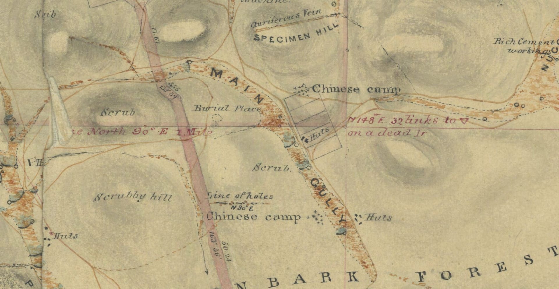
Source: Public Records Office Victoria – File GF31 Waranga Gold Fields 1857
The 1857 map also shows Chinese Gully/Flat just north of Moora Road (near the western end of Rushwoth) and running in a north-north-easterly direction. Presumably, Chinese alluvial miners had worked the area before 1857, which gave the gully its name, but the surveyor showed no indication of any Chinese camp at that locality. In his 1993 study of mining sites in the Waranga area2, David Bannear found no evidence of Chinese miners being there or any camp in that area.
The hill at the north end of the gully is still known as Chinamen’s Hill. It was the site of quartz mining but it is unlikely that the Chinese had much involvement in that. The quartz reef was opened up after being discovered by European alluvial miners in the gully.
By 1867, the location of one or more of the camps may have changed. A report in the Bendigo Advertiser stated that some quartz miners were working “the upper end of Old Red Hill, near the Chinamen’s camp”3 It is uncertain where “Old Red Hill” was, but the name could easily have changed over the years.
OTHER PLACES OF INTEREST
Despite the name, the so-called Mongolian Reef near Rushworth (about a mile or 1.6 km west of Growler’s Hill) was mostly mined by Europeans. The first to do so had been sold the rights to the site for £150 ($300) by Chinese alluvial miners who had discovered the reef while working in the area in 1867.4 The Chinese had briefly worked the site, getting good returns until they lost the “run of the stone”. Generally, the Chinese miners preferred alluvial mining, so they probably went back to that after selling their right to the site. There is no sign of a permanent Chinese camp in that locality.
It is clear from this that the Chinese miners explored plenty of potential new mining sites around Rushworth and Whroo, but for the reasons stated earlier, tended to camp together in groups.
References: 1 https://mapwarper.prov.vic.gov.au/maps/6264; 2 Bannear, David, Historic Mining Sites in the Rushworth-Waranga North Mining Division (Part 2: Site Gazetteer); 3 Bendigo Advertiser 9.9.1867; 4 Bannear p 43-4